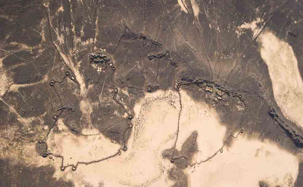
An aerial photo from Jordan of a pair of Kites. Image: Don Boyer
If there aren’t any aerial photos of the sites you want to examine, you can now turn to Google Earth.
Saudi Arabia has a rich archaeological history, but it’s one of the least explored parts of the Middle East. Professor David Kennedy from the University of Western Australia, is using Google Earth imagery to identify archaeological sites.
Professor Kennedy says that aerial reconnaissance is the single most powerful tool for locating and mapping archaeological sites. “Aerial archaeology has found thousands of sites that would otherwise have been unknown and in many cases have, since photographed, been damaged or destroyed.”
Aerial archaeology can reveal sites that aren’t visible from the ground, just by observing different soil colourations or how vegetation changes. But aerial imagery isn’t always readily available, so Professor Kennedy has turned to satellite imagery and the high resolution windows available on Google Earth.
“Google Earth is important for two reasons: first, it offers a seamless photomap of areas, regions … the entire world. Second, it offers high-resolution imagery of at least parts of some countries for which little or no aerial imagery is available.”
Archaeologists working in Britain have free, easy access to approximately 10 million aerial photographs, or can go and fly to collect images. But according to Professor Kennedy, Saudi Arabia, even more than many Middle Eastern countries, rarely makes aerial photographs available for archaeologists.
“In much of the world there is no such access to archive photos and no possibility of flying. Google Earth offers some opportunities and it may persuade national governments to liberalise their policies about access to aerial photos.”
Across the border from Saudi Arabia, Jordan contains sites from every period of history. Sites from roman times are very common, but in the Basalt Desert in the northeast there are also thousands of stone-built prehistoric sites.
“It was because of the latter that I decided to ‘look’ across the frontier into neighbouring parts of Saudi Arabia (KSA). Similar landscapes might have an equally rich harvest of sites.”
“The only way to do that was taking advantage of a few high-res ‘windows’ in Google Earth. That is what I have done and it has revealed thousands of similar stone-built structures.”
Some of the structures include Kites – a large animal trap with a ‘head’ and long ‘tails’, which animals were funnelled down until caught in the head. “Kites are well-known in Jordan and now we have large numbers from hundreds of kilometres further south in KSA of similar types but also of a type never seen in Jordan”.


